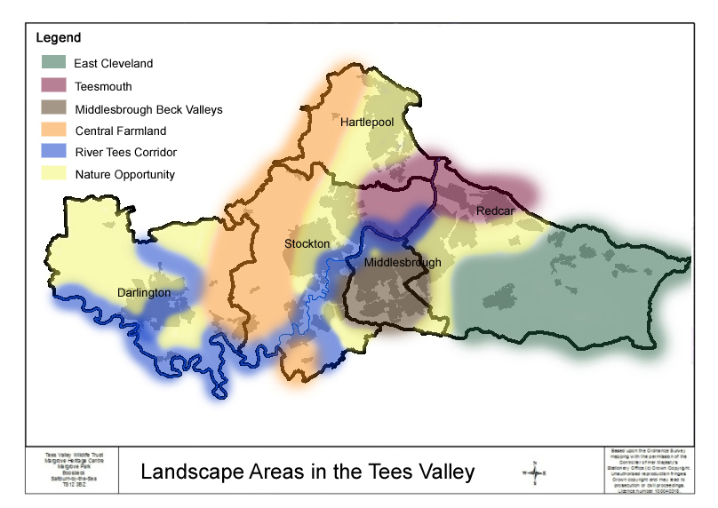
The importance of creating larger and better connected areas of natural habitat is now recognised as a key strategy for maintaining biodiversity and enabling wildlife to adapt to climate change. Many organisations are now promoting the creation of ecological networks and the use of landscape-scale approaches to conservation.
Making Space for Nature – more, bigger, better and joined up
The Making Space for Nature review of terrestrial wildlife sites in England argued that we must:
- improve the quality of current wildlife sites by better habitat management;
- increase the size of existing wildlife sites;
- enhance connections between sites, either through physical corridors or through ‘stepping stones’;
- create new sites; and
- reduce the pressure on wildlife by improving the wider environment.
In the Tees Valley we have identified five broad areas of landscape type:
The existing ecological and geological data sets for the Tees Valley have been brought together to produce maps of the habitats and species in each landscape area, the current area designations and a description of each areas ‘natural assets’ .
Landscape Area Maps & Descriptions – priority habitats and species
Landscape Areas Maps & Descriptions – designations
There are also maps, descriptions and designation lists for each local authority area:
- Darlington Local Authority Area
- Hartlepool Local Authority Area
- Middlesbrough Local Authority Area
- Redcar and Cleveland Local Authority Area
- Stockton-on-Tees Local Authority Area
Biodiversity Opportunity Area (BOAs)
The BOA’s comprise the key areas for potential biodiversity enhancement within the five larger areas of landscape type. This is where targeted maintenance, restoration, creation, mitigation and offsetting measures should be adopted to enhance biodiversity and in turn help to deliver a wide range of ecosystem services. Collectively the BOA’s form a strategic network, representing a significant environmental asset for the Tees Valley.
Each BOA has a map and accompanying statement. The maps are big pdf files that will take some time to download you need a good broadband connection. It is our intention to make GIS compatible documents available in the future.
- Central Farmland – pilot area
- Teesmouth – this area is being mapped in even greater detail for the Tees Estuary Partnership. See INCAs 2017 conference presentation on the Tees Estuary Habitat Framework
- Middlesbrough Beck Valleys (to follow)
- East Cleveland (to follow)
- River Tees Corridor (to follow)
Historic Phase 1 habitat maps for the Tees Valley
‘The Phase 1 habitat classification and associated field survey technique provides a relatively rapid system to record semi-natural vegetation and other wildlife habitats. Each habitat type/feature is defined by way of a brief description and is allocated a specific name, an alpha-numeric code, and unique mapping colour. The system has been widely used and continues to act as the standard ‘phase 1’ technique for habitat survey across the UK’. More information can be found from the JNCC (Joint Nature Conservation Committee).
The Tees Valley was surveyed and mapped in the early 1990’s. The original paper maps for Hartlepool, Redcar and Cleveland, Middlesbrough and Stockton (the historic Cleveland County) are held by the Tees Valley Wildlife Trust. Hartlepool has had a more recent survey and this map is held by Hartlepool Borough Council. Darlington (formerly a part of Durham County) paper map is in the archive at Durham County Council. These historic maps can only act as a guide and have been used to inform the BOAs. We recommend up-to-date site surveys need to be conducted particularly in regard to potential development sites.

